
Decisive Edge Newsletter | Digital Battlespace | June 2023
Newsletter Sponsors:


Turning the clock back? Why reverting to an older technology may be the best option for accurate timing signals in GNSS-disrupted conditions
The UK is poised to adopt a new timing system to help outflank attempts to disrupt global satellite navigation networks, according to a recent solicitation published by the country’s communications regulator.
The world has woken up to the significant disruption triggered by global navigation satellite system (GNSS) outages. Constellations like the US GPS, the EU’s Galileo, China’s Beidou and Russia’s GLONASS provide position, navigation and timing (PNT) signals.

These are used extensively across the world by civilians and militaries for navigation and to provide a reliable time signal.
The US government says the atomic clocks equipping its satellites provide accurate information to within 100 billionths of a second, which is enclosed in the GPS signal. This precise timing information is vital for accurate navigation and many other activities.
Despite global reliance on GNSS-delivered PNT signals, they are vulnerable to deliberate interference and are relatively easy to jam because they have been significantly weakened by the time they reach Earth.
PNT signals must perform a journey of circa 20,000km and satellites are space-constrained which limits the physical size of the signal amplifier they can accommodate.
The weak signal which reaches Earth can be exploited and attacked, and Russian land forces have notably deployed several GNSS jamming platforms to Ukraine. These include the R-330Zh Zhitel vehicle-mounted jammer.
Even at the R-330Zh’s maximum 30km range its power can be sufficient to ‘wash out’ a PNT signal so the GNSS receiver only ‘hears’ the jamming. Military systems use an encrypted M-Code PNT signal to help mitigate jamming, but this is unavailable to many users.
Such jamming is not confined to the battlefield. Persistent reports since 2014 have noted incidents of outages in Ukraine, the Baltic and around Syria, all areas where Russia has deployed forces or maintains a deep strategic interest.
GNSS jamming has also been blamed on China. On 23 May the GPS World publication said that aircrew had experienced GNSS disruption while overflying the South China Sea, with the source said to be People’s Liberation Army Navy warships navigating in these areas.

These inherent vulnerabilities are prompting a rethink regarding PNT provision around the world. The intention is not necessarily to replace GNSS, but there is an emphasis on providing similar services should PNT signals suffer interference in a particular area.
Enhanced Long Range Navigation (ELORAN) is one such technology garnering interest. This is an enhanced version of the LORAN-C radio navigation system which fell into disuse in the 1990s as GNSS networks gathered momentum.
LORAN-C employed an elegantly simple principle. Two radio transmitters were placed a set distance apart and their location marked on a map for the user. Each transmitter sent out a pulsed signal with a set delay on a specific frequency, and a ship or aircraft within range would receive the two signals and triangulate its position.
ELORAN is an enhancement of this architecture with the addition of a signal that transmits precise timing information, so a single transmitter can be used to provide a time signal. Two or more transmitters can then provide navigation information.
Using a single ELORAN transmitter to provide a time signal is a useful alternative to relying on GNSS. Moreover, the ELORAN signal uses frequencies of 90-110KHz and can travel hundreds of miles:
That single transmitter providing a time source could ensure such a service across a very large area, even an entire country.
In May, OFCOM, the UK’s communications regulator, launched a consultation regarding a national ELORAN system. OFCOM licenses operators to use specific wavebands in the radio spectrum, used for everything from television broadcasting to provision of radio landing aids at airports.
Official documents say the regulator plans to make spectrum available in the 90-110KHz waveband, with OFCOM licencing commercial ELORAN operators. The regulator told Shephard in a written statement that ‘at present, there is no OFCOM spectrum licence product available which is suitable for authorising the deployment of an ELORAN system in the UK’.
Andy Proctor, director of RethinkPNT, expects the UK’s initial ELORAN infrastructure to initially employ one transmitter to provide a timing signal. Indeed, there is an old LORAN-C transmitter at Anthorn, Cumbria in northern England. Whether this transmitter could provide the timing signal remains to be seen.
Proctor said that this equipment would require significant upgrade work to make it fit for purpose. OFCOM’s statement noted that the ‘consultation will remain open until 14 July 2023. Once the consultation is closed, we will review all the responses we receive. We will then publish a statement setting out our decision on whether to proceed with our proposals.’

Above: Dependence on GNSS networks such as Galileo for PNT leaves multiple areas of defence and the wider economy susceptible to jamming, so alternatives are needed. (Image: ESA)
Following the consultation, Proctor said that ‘the next step could then see the government granting OFCOM the ability to award a licence’ to provide an ELORAN signal. He estimated that this could be awarded in as little as six months once the next part of the process is complete.
Once a licence is awarded, a commercial operator could be ready to provide the timing signal service within two years. Adding a second transmitter could enable provision of navigation and position services within five years, he added.
The business model would be for a commercial operator to purchase a licence from OFCOM to operate the service and then sell access to the timing signal.
Nick Lambert, co-founder and director of NLA International, broadly welcomed the UK’s interest in ELORAN but argued it should be part of a more holistic solution: ‘We need to move beyond the GNSS concept towards a global, resilient PNT system.’
He proposes reinforcing GNSS with capabilities like ELORAN and emerging concepts such as quantum navigation. Lambert foresees a ‘black box’ which could equip vehicles, ships and aircraft, and organisations and people dependent on reliable PNT with several such capabilities.
These boxes could receive GNSS and ELORAN signals, and possibly also include an inertial navigation system. This would give several layers of redundancy.
Ultimately, the UK’s embrace of ELORAN is an important step in the right direction but, as Lambert argues it should be one of several capabilities: ‘We should not be waiting for a catastrophe to say we really need resilient, global PNT. This is fundamental to the global economy.’
Getting the picture – how the US Army is safeguarding NATO air sovereignty in the Baltic
More details have emerged regarding the US Army’s Forward Area Air Defence (FAAD) C2 system which has been deployed to the Baltic to strengthen key regional air defences.
FAAD helps protect Estonian, Latvian, Lithuanian and Polish airspace and air approaches to these countries, as well as deployed NATO forces.
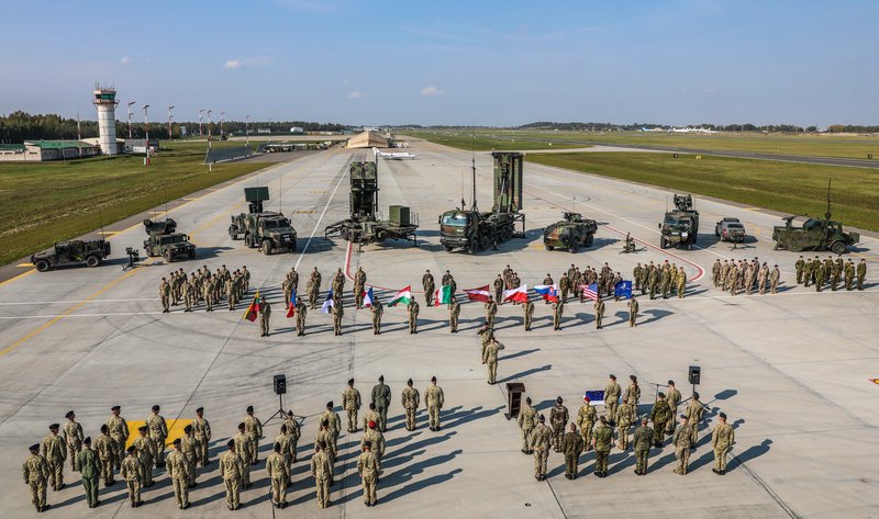
Above: NATO’S Enhanced Forward Presence in the Baltic includes air defence capabilities from a wide array of member states, making the C2 connective tissue of FAAD a vital asset. (Photo: US Army)
The alliance has what it refers to as an Enhanced Forward Presence in these nations, taking the form of four multinational battlegroups stationed in the three Baltic nations with an additional one in Poland.
This arrangement resulted from (usefully prescient) decisions taken during NATO’s Warsaw Summit in 2016, and according to the alliance, around 1,000 troops are permanently deployed to these countries.
As well as facing potential threats from Belarus and Russia, the region is home to the Suwalki Corridor, a 65km strip of land along the Polish-Lithuanian border. It is flanked to the northwest by Russia’s Kaliningrad exclave and by Belarus to the southeast.
A ‘nightmare scenario’ for NATO is that Russian troops in Kaliningrad and their Belarussian allies close the corridor. Such a manoeuvre would effectively cut Estonia, Latvia and Lithuania off from Poland and their other NATO allies to the west.
With all this at stake, what role does FAAD play? The Northrop Grumman-manufactured system is designed to provide C2 for short-range air defence (SHORAD), including counter-UAS capabilities.
FAAD federates track data provided by dispersed sensors to develop a recognised air picture (RAP). The status of effectors like surface-to-air missiles and C-UAS systems connected to FAAD can be overlaid onto the RAP. In addition to conventional air defence, FAAD can manage counter-rocket, artillery and mortar systems.
The system uses several links to federate its associated sensors and effectors. These include NATO’s Link-11 and Link-16 Tactical Data Link (TDL) protocols, mainly used to support naval and air operations respectively.
FAAD also handles NATO’s Joint Range Extension Application Protocol (JREAP), a tactical messaging standard used by long-range links like satellite communications. An important aspect of FAAD is that these TDL protocols allow it to link outwards to other C2 systems. This lets the RAP be shared with other battle management systems.
Northrop Grumman told Shephard that ‘the coordination of forward area air defence is critical’ to force protection in this region. The system provides a mechanism to efficiently manage SHORAD should these countries, or forces deployed there, be attacked.
Interoperability is also a high priority given the disparate capabilities that plug into FAAD, which could be from virtually any NATO member as well as the host nations.
Mike O’Hara, Northrop Grumman’s FAAD programme manager, emphasised the system’s tactical flexibility, saying that it can be deployed from brigade level downwards. The US Army divides air defence responsibilities between FAAD and the Integrated Air and Missile Defence Battle Command System (IBCS). Northrop Grumman is also providing the latter.

Above: The FAAD system has been deployed to several Baltic nations. It provides overarching C2 for SHORAD sensors and effectors and can link outwards to air defence C2 systems at other echelons or those deployed with allied forces. (Photo: US Army)
IBCS will provide brigade-level air defence C2, while FAAD will support air defence for dismounted and manoeuvre units in addition to the C-UAS mission, O’Hara continued.
He added that the system is sensor- and effector-agnostic via the use of ‘open architecture [and] non-proprietary interfaces to enable the easy integration of additional radars and sensors’. To this end, he said that work is ongoing to increase the breadth of sensors and effectors FAAD can work with. Other enhancements include the addition of operator decision aids in the future.
Hopefully this flexible capability will contribute materially to offering enough of a deterrent to prevent the alliance’s ‘nightmares’ coming true.
Faraway places – why over-the-horizon radar is still a key asset for the US Navy
Improvements are in the offing for the USN’s two AN/TPS-71 Relocatable Over-the-Horizon Radars, better known as ROTHR, which entered service in 1991.
For long-range detection of ships and aircraft, these arrays use HF transmissions aimed towards the ionosphere, between 48 and 965km above the Earth’s surface.

Above: The USN originally deployed its AN/TPS-71 radar to the Aleutian Islands to keep tabs on military activity in the eastern Soviet Union. Two of these radars now provide counter-narcotics surveillance across the Caribbean and Gulf of Mexico. (Photo: USN)
The transmissions cannot get through this atmospheric layer and, because of this, are refracted back towards the ground. By aiming at an angle towards the ionosphere, the radar can exploit the refraction and bounce the transmissions back down to the surface, as light refracts when shone through a block of glass.
Exploiting refraction allows the radar to avoid the curvature of the Earth and hence detect targets hundreds, or even thousands, of kilometres away.
The USN installed a single AN/TPS-71 on the island of Amchitka in the Aleutian archipelago in the northern Pacific Ocean back in 1991 to monitor Soviet military activity. This became a casualty of the ‘peace dividend’ at the end of the Cold War, being dismantled in 1993.
That same year, another radar was deployed to Chesapeake, Virginia on the eastern seaboard of the US, tasked with providing surveillance of the Caribbean and Gulf of Mexico to aid US counter-narcotics efforts. Another AN/TPS-71 was deployed to Corpus Christi, Texas in 1993, enhancing coverage of the maritime approaches to the southern US, also to help counter drug smuggling.
Open sources state that the AN/TPS-71 uses frequencies of 5-30MHz which give detection ranges of between 930 and 2,960km, translating to a surveillance footprint of 5.6 million sq km.
The same sources say that an AN/TPS-71 can determine a target’s location within 6km of range and 15km of azimuth. While this is less precise than radars using higher frequencies, it is enough to provide indication of where a potential target is located.
This can then be investigated in more detail by other assets like maritime surveillance aircraft or ships.
The two remaining AN/TPS-71 radars are now receiving upgrades to ensure their capabilities remain sharp. On 14 June, the USN awarded Raytheon an $87.5 million contract to upgrade both to improve their detection of maritime targets.
Augmenting these capabilities will be an important enhancement given the propensity of narcotics traffickers to use small, fast boats which can be otherwise difficult to detect with radar.
Raytheon told Shephard via a written statement that the upgrade work will begin this August and should conclude in August 2027. Its scope will include improvements to both the radar’s software and hardware.
The statement added that Raytheon expects the radars to remain in service for the foreseeable future, and that further future upgrades to keep their capabilities honed are expected.
Beyond the AN/TPS-71, Raytheon said it is using OTH radar technology to develop a new cruise missile detection radar, adding that it expects to share details of this new system in the near future.
Don't want to miss out on future Decisive Edge content? Make sure you are signed up to our email newsletters.


